Hiking in Larmor Baden, Locmiquel and the Seven Islands
Larmor Baden – Locmiquel – les Sept Îles
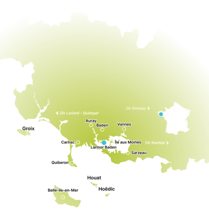
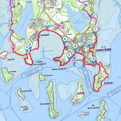
This hike starts in the village of Larmor-Baden and leads to the Île des Sept Îles in the commune of Baden. Most of the paths are coastal paths (GR34). View of the coast, the entrance to the Golfe du Morbihan and the islands (Île aux Moines, Île de Berder, Île de Gavrinis).
- Start: crossroads of Rue du Moulin and Rue de Pen en Toul in Larmor Baden, Golfe du Morbihan
- Running time: 2h55 (easy)
- Distance: 10.18km
- Difficulty: easy
The walk starts at the crossroads of Rue du Moulin and Rue de Pen en Toul.
(D/A) Turn left on Chemin du Moulin (following the GR) and then right on Chemin de Kerledan.
(1) Take the GR to the right before the chicane. Follow the road to the right and go straight ahead.
(2) Turn left on Rue de la Montagne and left again on Rue du Drenez. Go straight ahead until you reach the Île de Berder jetty. Depending on tide times, you can walk around the island (note that the path is only accessible at low tide; see the information panel indicating these times). A coastal path leads around the island, but the center is private and not normally accessible. As for us, we continue straight on towards the port of Larmor.
(3) Before the first house, turn left down to the beach. Beautiful view of Île aux Moines and Gavrinis. At the end of the beach is an orientation table. After the port, follow the path along the coast, passing under the parking lot.
(4) At the end of the beach path, keep left (if you turn right, you can go up into the village of Larmor-Baden, where you’ll find supplies, a café and a bakery). Follow the Port Lagaden road and pass it.
(5) At Berchis beach, follow the coastline and take the stairs on the left.
(6) At Paludo beach, take the path on the left, then opposite. Follow the beach, but at high tide, it may be difficult to get through.
(7) Follow the road to Locmiquel (Chemin du Carheu) then follow the seafront.
(8) At the exit, take the road to the left. At the next crossroads, follow the road to the left. At the end of the road, take the path opposite. Nice view of the entrance to the gulf. After the track, take the left-hand road
(9) Turn left onto the road. At the end of the road, turn right. You’ll come to an intersection with a road called Route des Sept Îles. You can drive around it at low tide (the sandy passage is covered at high tide) (A).
Passage points :
- D: km 0 – alt. 18m – Rues du Moulin and de Pen en Toul
- 1: km 0.17 – alt. 19m – Chemin de Kerledan
- 2: km 0.81 – alt. 21m – Rue de la Montagne on the left
- 3: km 4.05 – alt. 8m – Descent to the beach
- 4: km 4.98 – alt. 4m – Chemin de Port Lagaden
- 5: km 5.32 – alt. 4m – Berchis beach
- 6: km 6.76 – alt. 1m – Paludo Beach
- 7: km 7.57 – alt. 4m – Locmiquel (chemin du Carheu)
- 8: km 8.65 – alt. 6m – Carrefour
- 9: km 9.71 – alt. 10m – Carrefour
- A: km 10.18 – alt. 1m – Route des Sept îles


