Hiking in Larmor Baden and Île Berder
Larmor Baden – Berder Island
In the heart of an oyster-farming basin, Larmor-Baden offers a wide range of discoveries: Île Berder, accessible at low tide, the pier for the famous Cairn de Gavrinis, and views of the many islets. Set back from the sea, the ornithological reserve of the Marais de Pen en Toul.
- Start: church parking lot, Larmor Baden, Golfe du Morbihan
- Running time: 2:05 (easy)
- Distance: 7.14km
- Difficulty: easy
Out of beaconing
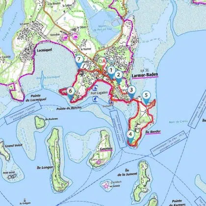
Turn right around the church onto Rue du Vieux Four, which continues on the right into Rue de Berder.
(1) At a hotel, turn left into Rue Parc Fetan, then right into Rue du Verger.
(2) At the crow’s-foot, turn left into Ruelle Etal Berder, which continues on the left into Rue Traversière. Turn right to go down to the ford leading to Île Berder (see practical information for tide conditions).
(3) Cross the ford and immediately turn right onto the wide, counter-clockwise path around the island. The path is shaded by old maritime pines. At tide level, you can see the oyster beds. Continue to the southern tip: view of the impressive “La Jument” sea current, Europe’s second strongest. To the right, views of Gavrinis and Er Lannic islands.
(4) Continue along the coastal path to discover the east coast. On your right is Île-aux-Moines, the largest in the Gulf of Morbihan. The path winds between venerable trees. At the northeastern tip, discover the Chapelle Sainte-Anne, built in 1865 (now closed).
(5) The path skirts a wide cove. Oyster beds abound in this area. Reach the ford, cross it again and then (3), turn left onto the coastal path up Rue de Berder.
GR34 markings (White and Red)
Go around the harbor cove, past the pier for the Cairn de Gavrinis and follow Rue de Pen Lannic. Turn left onto the coastal path around Port Lagaden cove. Continue to join the Chemin de Port Lagaden, which skirts an oyster-farming area on the right and continues to the Pointe de Berchis.
(6) The path skirts a private property to the right, then continues along the Anse de Locmiquel. On the other side, you can see the headland of the same name. Continue along a beach, pass behind houses and join Rue du Paludo.
Out of beaconing
(7) Follow this street to the right, leading to the church and its parking lot (D/A).
Passage points :
- D/A : km 0 – alt. 11m – Church parking lot
- 1 : km 0.25 – alt. 10m – Hotel, Rue Parc Fetan
- 2: km 0.47 – alt. 16m – Left, Ruelle Etal Berder
- 3: km 0.97 – alt. 5m – Ford crossing
- 4: km 2.05 – alt. 7m – View of the “La Jument” stream
- 5: km 3.47 – alt. 3m – Large oyster farming area
- 6: km 5.57 – alt. 3m – Pointe du Berchis, bypass private property
- 7: km 6.67 – alt. 1m – Leave the seafront on the right Rue de Paludo
- D/A : km 7.14 – alt. 11m – Church parking lot


